20/101
Accueil /

satellite_image_spot5_2.5m_rhone_river_france_2003

flickr-30775505572.jpg satellite_image_spot6_toulouse_france_2012Miniaturessatellite_image_spot5_2.5m_st_martin_island_france_2006satellite_image_spot6_toulouse_france_2012Miniaturessatellite_image_spot5_2.5m_st_martin_island_france_2006satellite_image_spot6_toulouse_france_2012Miniaturessatellite_image_spot5_2.5m_st_martin_island_france_2006satellite_image_spot6_toulouse_france_2012Miniaturessatellite_image_spot5_2.5m_st_martin_island_france_2006satellite_image_spot6_toulouse_france_2012Miniaturessatellite_image_spot5_2.5m_st_martin_island_france_2006satellite_image_spot6_toulouse_france_2012Miniaturessatellite_image_spot5_2.5m_st_martin_island_france_2006satellite_image_spot6_toulouse_france_2012Miniaturessatellite_image_spot5_2.5m_st_martin_island_france_2006

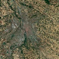
L’embouchure du Rhone par le satellite Spot 5 en 2003 (Copyright: CNES, Distribution Airbus DS)

Auteur
rêves d espace
Visites
1657

0 commentaire